La Niña and the polar vortex set to deliver a truly Canadian winter
The Weather Network’s 2025-2026 Winter Forecast
OAKVILLE, Ontario, Nov. 26, 2025 (GLOBE NEWSWIRE) -- Canada enjoyed an exceptionally mild fall, but a dramatic flip in the jet stream pattern is underway with an expected chilly start to the winter season across the country. Will La Niña and a disrupted polar vortex team up to lock-in this pattern for the rest of winter?
To answer that question, The Weather Network has released their winter forecast for the months of December, January and February.
“An exceptionally early disruption of the polar vortex has set the stage for a steady supply of arctic air into southern Canada during December and into January,” said Doug Gillham, senior meteorologist at The Weather Network. “In addition, La Niña has returned. While last winter featured a weak La Niña pattern, a slightly stronger version of La Niña has emerged for the encore performance. This combination should deliver a truly Canadian winter for most of the country.”
At this point it is unclear whether the widespread cold pattern will continue to dominate through February, or if the focus of winter’s fury will shift to western Canada with a more changeable pattern for eastern Canada for the second half of the season.
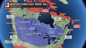
Regardless, most of Canada is expected to see a more traditional Canadian winter with near normal or colder than normal temperatures. Parts of Atlantic Canada and far northern areas have the best chance of seeing above normal temperatures.
An active storm track should deliver near normal or above normal precipitation and snow totals to most of Canada.
Here’s a more detailed look at what we can expect across the country during the upcoming winter season:
British Columbia
A cold winter is expected across the eastern half of the province with a heightened risk for periods of severe cold. Coastal areas should be close to normal, but there is a risk for arctic outflow events. The storm track will be inconsistent with stretches of dry weather interspersed with active periods with moisture laden storms that should bring precipitation and snow totals close to normal for most of the province. However, the north coast is expected to be drier than normal, while above normal snowfall is expected for the Kootenays and Rockies. The risk for Pineapple Express events, which usually brings heavy rain to the alpine regions, is lower than normal.
Prairies
A very cold winter is expected across the region. While the frigid pattern will relax at times, colder-than-normal temperatures are expected to dominate with a heightened risk for extended periods of severe cold. Near-normal snowfall is expected across most of the region with a threat for blizzard conditions at times, while above-normal snow totals are expected for southwestern Saskatchewan, across southern Alberta and into the southern Rockies and foothills.
Ontario and Quebec
A cold start to the season is likely with more winter weather leading up to and through the Holidays than residents have been accustomed to seeing in recent years. Colder than normal temperatures are expected well into January, but the pattern could become more changeable during the second half of winter with the potential for an extended stretch of milder weather. An active storm track should bring near normal or above normal precipitation and snowfall to the region, but southern areas will see messy storms at times with a risk for ice and even rain, especially during the second half of the season.
Atlantic Canada
A changeable winter is expected across the region with stretches of very cold weather (especially during the first half of the season) offset by periods of milder weather. Southern Nova Scotia and most of Newfoundland and Labrador have the best chance of seeing above normal temperatures overall, especially later in January and February. Near normal precipitation is expected during a season that is known for being very active, and this will include a few high impact winter storms. However, Nova Scotia and eastern Newfoundland could see below normal snow totals due to more messy storms that include ice and rain.
Northern Canada
Near normal temperatures are expected across the Yukon and the NWT, but much of Nunavut will see less severe cold than typical during winter across this region. Near normal snowfall is expected for most of the region, but below normal snow totals are expected for southern parts of the Yukon. A more changeable pattern is expected through the season with a risk for more windy days and ground blizzard conditions.
| The Weather Network: Winter 2025-26 Forecast | ||
| Region | Temperature outlook | Precipitation outlook |
| British Columbia |
Near normal west; Below normal east |
Near normal; Above normal southwest; Below normal north coast |
| Alberta |
Below normal |
Above normal south; Near normal central and north |
| Saskatchewan |
Below normal |
Near normal; Above normal southwest |
| Manitoba |
Below normal |
Near normal |
| Ontario |
Below normal; Near normal southwest |
Above normal south; Near normal north |
| Québec |
Below normal south and west; Near normal east |
Above normal south; Near normal elsewhere |
| The Maritimes and Newfoundland |
Above normal southern Nova Scotia, Newfoundland and eastern Labrador; Near normal elsewhere |
Near normal |
| Yukon, Northwest Territories, Nunavut |
Near normal Yukon, NWT and southern Nunavut; Above normal central and northern Nunavut |
Near normal; Below normal southern Yukon |
Canadians can check daily forecasts by visiting www.theweathernetwork.com or by downloading The Weather Network App available on iOS and Android, and creating an account for personalized and up-to-the minute forecasts.
Complete winter forecast details, including regional breakdowns, maps and charts are available on our seasonal page at theweathernetwork.com/winter.
Interview opportunities: The Weather Network meteorologists are available for interviews between Nov.26-28 to provide additional details and localized insights about this year’s winter forecast.
To arrange an interview with a meteorologist, please contact:
Madelaine Lapointe
mediainquiry@pelmorex.com
About Pelmorex
Pelmorex is the company behind the well-known trusted weather brands, The Weather Network, MétéoMédia, Eltiempo, Otempo and Clima. Its mission is to provide fast, accurate weather forecasts, personalized insights and critical weather alerts, empowering people, communities and businesses worldwide to make informed decisions amidst the changing weather. This core intelligence is extended through Pelmorex Weather Source, its enterprise division, which helps companies turn weather uncertainties into strategic advantages. Pelmorex is also a key public safety partner and operates Canada’s National Alert Aggregation and Dissemination System, part of the Alert Ready emergency alert system.
To learn more, visit Pelmorex.com and follow us on LinkedIn.
Photos accompanying this announcement are available at:
https://www.globenewswire.com/NewsRoom/AttachmentNg/3cc8b214-12ee-44ea-b35c-32cde24cc244
https://www.globenewswire.com/NewsRoom/AttachmentNg/8977b77d-e0e2-4bbd-8220-44d9f45fbae9

![]()
Winter forecast - Temperature
The Weather Network’s 2025-2026 Winter Forecast
Legal Disclaimer:
EIN Presswire provides this news content "as is" without warranty of any kind. We do not accept any responsibility or liability for the accuracy, content, images, videos, licenses, completeness, legality, or reliability of the information contained in this article. If you have any complaints or copyright issues related to this article, kindly contact the author above.
